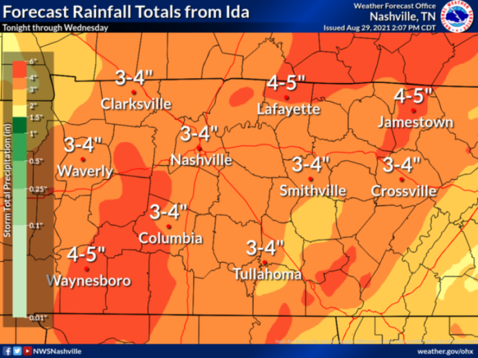
UPDATE from NWS: Aug 31: 8:45pm
The flash flood watch has been canceled. Some light rain will continue Tuesday evening mainly along and east of I-65, but the threat for flooding has ended. Many places ended up getting 2 to 5 inches of rain from Ida, and NWS have a final list of rainfall totals tomorrow.
UPDATE from NWS: Aug 31, 7:30am
Showers and storms will continue throughout the day Tuesday. Flash Flooding will continue to be a threat as heavy rain falls on saturated grounds.
A Flash Flood Watch is in effect until 1 AM Wednesday.
As of 3AM Tuesday Morning: Most of Middle TN had received from 0.25 to 2 inches of rain
with isolated areas receiving 3 inches. An additional 2” to 4” of rain is expected Tuesday.
Impacts: Showers and storms will continue to move across Middle TN throughout the day. Flash flooding remains the biggest concern with this system, as additional rainfall amounts of 2” to 4” are possible. Gusty winds upwards of 20 to 30 mph will be possible today and Wednesday. The threat for severe storms and weak tornadoes has decreased and remains limited to areas along the Cumberland Plateau.
Timing: Heaviest rain from now through early afternoon. Expect rain to taper off from west to east this evening. Rainfall should mostly diminish by early Wednesday morning.
Original Story Published Aug 30
Hurricane Ida will bring heavy rainfall to most of the area Tuesday.
The National Weather Service (NWS) has issued a Flash Flood Watch for portions of Middle Tennessee for 7pm Monday evening through 1am Wednesday
The following areas are in the Flash Flood Watch: Bedford, Cheatham, Clay, Davidson, Dickson, Giles, Hickman, Houston, Humphreys, Jackson, Lawrence, Lewis, Macon, Marshall, Maury, Montgomery, Perry, Robertson, Rutherford, Smith, Stewart, Sumner, Trousdale, Wayne, Williamson and Wilson.
NWS Forecast Details
Remnants of Ida will begin to arrive to Middle TN from the southwest Monday evening. Showers and t’storms will become widespread on Tuesday before moving off to the northeast early on Wednesday.
➢ Flash flooding is possible, especially on Tuesday as the heaviest rain moves through.
➢ Widespread 2” to 4” is expected with locally higher amounts upwards of 6” possible.
➢ Storms producing damaging winds & isolated tornadoes cannot be ruled out late Monday into early Tuesday.
➢Ida will move out of our area by Wednesday evening, leaving behind drier conditions.
Key Forecast Points for Ida:
Impacts: Showers and t’storms will begin in our southwestern counties on Monday afternoon before spreading northeast overnight into Tuesday and ending Wednesday.
Flash flooding is the biggest concern with this system, as widespread rainfall amounts of 2” to 4” is possible will locally higher amounts.
Cannot rule out severe weather (damaging winds / isolated tornadoes) late Monday into Tuesday, but this is highly dependent on Ida’s eventual path.
Gusty winds upwards of 20 to 30 mph will be possible Tuesday and Wednesday.
Timing:
Late Monday through Wednesday morning. Heaviest rain expected Monday Night through Tuesday


