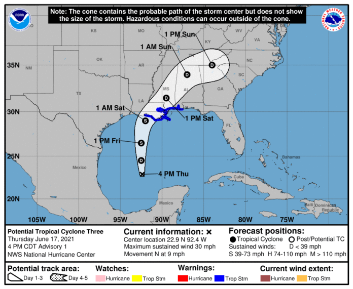
From the NWS Hurricane Center:
880
WTNT43 KNHC 172034
TCDAT3

Potential Tropical Cyclone Three Discussion Number   1
NWS National Hurricane Center Miami FL       AL032021
400 PM CDT Thu Jun 17 2021

Visible satellite images show that the cloud pattern associated with
the broad area of low pressure located over the southwestern Gulf of
Mexico is gradually becoming better organized.  Deep convection is
beginning to form a broad curved band over the eastern portion of
the system, similar to what one might see in a developing
subtropical cyclone.  Although the upper-level winds are not
particularly favorable for development, with lots of westerly shear
over the area, the global models do suggest tropical/subtropical
cyclogenesis within the next 12 hours or so.  Given the proximity of
the disturbance to land, which requires tropical storm warnings at
this time, advisories are being initiated on this system as a
potential tropical cyclone.

Earlier scatterometer data suggested that the circulation was still
rather broad.  An Air Force Hurricane Hunter plane is currently
investigating the system and has not yet found a well-defined
center.  Maximum winds based on surface observations and the
scatterometer pass are near 25 kt.  Numerical intensity guidance do
not indicate a great deal of strengthening before the system
reaches the coastline, and the official forecast is at the high end
of the guidance.

Since the center is not that well-defined at this time, the initial
motion estimate, 360/8 is quite uncertain.  The system is expected
to move northward into a weakness in the subtropical ridge for the
next day or so and then, after landfall along the central Gulf
Coast, turn toward the northeast on the northwest side of a
mid-level anticyclone near Florida.  The official track forecast is
closest to the GFS and ECMWF predictions.  It should be noted,
however, that these models suggest some reformation of the center
near the Louisiana coast rather than just motion from the southwest
Gulf to the expected coastal landfall point.

Given the current and anticipated structure of this system, users
should not focus on the exact track of the center, as rainfall and
wind hazards are likely to extend well east of the center and arrive
well in advance of landfall.

Key Messages:

1. The system is expected to produce heavy rainfall and considerable
flash, urban, and small stream flooding beginning Friday and
continuing through the weekend along the central Gulf coast and
spreading northeastward into the Southern Appalachians.

2. Tropical storm conditions are expected to begin Friday in areas
near and well to the east of the center along portions of the
central Gulf Coast from Intracoastal City, Louisiana, to the
Alabama/Florida border, including New Orleans.
Up to the minute, updates and weather watches and warnings powered by ReadyWarn can also be found on our Facebook page and Twitter. Or have our daily e-mail with weather and more delivered to your e-mail box each morning and afternoon by signing up on our homepage.
See our live weather radar here.
https://wilsoncountysource.com/noaa-another-active-hurricane-season-in-2021/


