
The latest forecast from National Weather Service (NWS):
- Rainfall totals of 3 to 5” expected between Wednesday and Thursday, with the bulk of it coming after midnight Wednesday
• Total amounts higher than 5 inches possible in the circled area above, but Flash Flooding could occur ANYWHERE in the watch
• Rivers and creeks likely rising to minor or even moderate flood stage by Friday morning
• Rivers will remain high going into this weekend
• Confidence: High
Live Weather Radar
Freezing Rain Potential
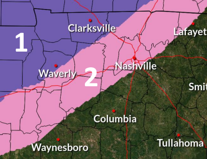
problems and power outages
In areas marked as 2: Up to a 1/10” of ice is possible. If this occurs, expect travel problems and scattered power outages
Key Forecast Points for Thursday Night
Forecaster Comments:
• Models are trending upwards with the ice totals in the far northwest
• There is still uncertainty on how fast the rain will transition to freezing rain. This could affect totals in all areas.
• A tight gradient of ice accumulations is likely north and west of Stewart County
• Even non-highlighted areas of Middle TN could see very light ice accumulation before midnight, so there may be at least minor travel impacts everywhere in Middle TN Friday morning
For up to date traffic conditions find your live traffic map below:


Subscribe to our FREE Newsletter